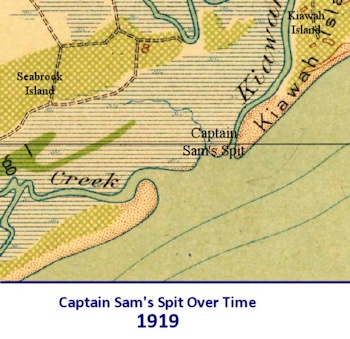
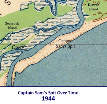
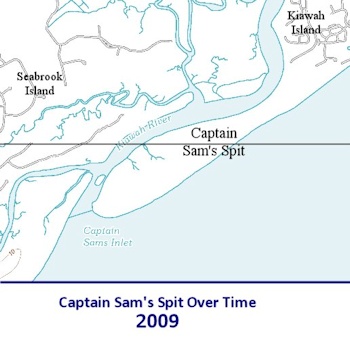
Click to see changes over time. Source: USGS maps
The Captain Sam’s Spit development issue is back in the news. The SC State Supreme Court surprisingly
reversed themselves and will allow the building of a half mile long revetment / seawall along the Kiawah River at the narrowest part of the Spit. The revetment wall is the first step in building 50 homes on the Spit. The next step will be to build a road which will go through the Beachwalker County Park’s parking lot and significantly reduce the available parking
1. Development of Captain Sam’s Spit does not make sense either ecologically or economically.
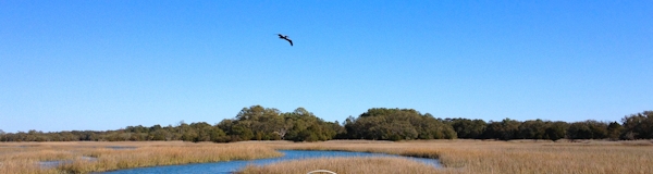
The Sam’s Spit development will affect wildlife on Johns Island’s southern border throughout the Kiawah River. Our unique family of two dozen dolphins will be especially affected as the location of the seawall is right in the middle of their prime feeding ground. The construction activity and dense human occupation at the mouth of the River will also affect all the creeks and salt marsh area throughout the Kiawah River system (see “
World of the Salt Marsh†by Charles Seabrook ). The environmental impact, destruction of wildlife (turtles, dolphins, plovers, bobcats etc.) and loss of recreational opportunity for the general public are enough reasons for action to prevent this development.
But maybe more importantly, or more persuasive to the developers and potential homeowners, is that this development just does not make economic sense. All exposed beach areas along the East Coast, and the Spit in particular, are
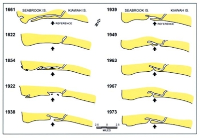
highly unstable. Sam’s Spit did not exist in
1822, 1920 and 1950. Photographs as late as 1974 show it was only a sandbar at that time
2. The Ocean Coastal Resource building setback line on the Spit was redrawn only ten years ago to even allow the Town of Kiawah to consider the development. Before then the Spit had zero, $0, development value. But apparently history is irrelevant or is thought to extend back only ten years.
So look what’s happened in the last two years.
Folly Beach County Park was blown away. Hurricane Irene redrew the map on the Outer Banks
two years ago. And just last week,
again. ). Hurricane Sandy? 2012? Anybody remember?
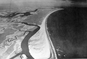
Sam’s Spit in 1974 – no buildable land
Sams Spit has already been denied Federal flood insurance which means all houses on the Spit must be self-insured. The last thing we need in SC is another hurricane. But anything built there will most likely be swept away in the next ten or twenty years if not sooner. With that threat, who’s going to buy a million dollar home without insurance or financing? What if the developer themselves get caught during construction? Why would they want to take that risk? Certainly no bank would lend them or prospective homeowners money in today’s financial climate. Why don’t they put a reasonable non-development price on Sams Spit and let a government or non-profit consortium buy it and preserve the Spit? (Or better yet donate it; it cost them nothing in 1988.) Why is this development even being considered? What ARE they thinking?
- The Beachwalker County Park property is actually owned by the Kiawah developers and is on a 99 year lease granted by the previous owners of Kiawah.
- A very detailed environmental study of all off Kiawah Island was done in 1974 by the previous developer. The current developer touts this study on their real estate website. They do not mention that the 1974 study called Sam’s Spit “unstable†and includes a series of maps that show over centuries, and as recently as 1950, just how unstable Sam’s Spit is. A copy of the study is available in the South Carolina Room of the Charleston County Main Library downtown on Calhoun St.