Johns Island at the Crossroads
Land Use and Development
Between 2000 and 2010 Johns Island grew by 50%, from a population of 11,200 to over 17,000. Part of this growth has been a result of the expansion of the City of Charleston onto the island over the last two decades. The rapid development of neighboring resort islands beginning about 1970 has also significantly impacted Johns Island. Everyone traveling to and from Kiawah and Seabrook – residents, workers and visitors – must pass through Johns Island. In addition to affecting land values and use patterns, these changes have put new pressure on Johns Island’s traditional character and its infrastructure.
The recession of 2007-09 slowed development activity. But as the recovery from the financial crisis continues, the pace of investment and construction on Johns Island and its neighboring islands is quickening. The future character of Johns Island will be determined by how this development is managed.
Planning for the future of Johns Island requires understanding current patterns as well as projects already approved and planned. To help residents and concerned citizens in researching and understanding the issues that face the island, the Conservancy undertook to consolidate the best available resources into a single set of interactive maps, links and database resources. The unique interactive map of Johns Island has nine overlay layers that display a variety of useful data and links directly to a customized zoning regulation database.
Land Use Map Overlays
County Zoning Regulations (Unincorporated)
Johns Island is 84 square miles making it the fourth largest island on the US East Coast (after Long Island, NY; Mt. Desert ME; and Martha’s Vineyard, MA). Johns Island is divided into more than 10,000 different properties ranging from as large as 1,000 acres to individual condominium and townhouse units, some on properties as small as a couple of thousand square feet. There are currently an estimated 8,000 dwelling units, with thousands more already approved in planned developments. Approximately 5,000 more could also be built under existing zoning. Unchecked, a built-out Johns Island could eventually number well over 20,000 homes.
When counted as individual parcels, the vast majority of the properties on Johns Island are residential. When viewed by area, however, it becomes clear that many larger properties are still undeveloped and devoted to more traditional activities such as agriculture, timber and horse farming. There are also many “estate†sized residences of 3 – 5 acres and more. The island also has its share of commercial properties and a good size executive airport.
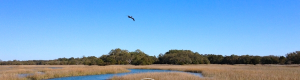
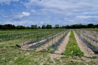 Johns Island has traditionally been rural and agricultural. During the second half of the 20th century, the island was famous for its tomatoes, which were grown in large numbers. Before then, potatoes, or “Irish potatoes†as they are known in census records, were grown. The huge DiMare packing plant on Main Road and a smaller facility on Brownswood Road, stand as mute evidence to the extent of agricultural activity. Both buildings now all but abandoned. There was also a railroad line active in the early twentieth century that ran across the northern part of the island. The line was built and used mainly to ship produce (see “Historic Map†overlay).
Many people move to Johns Island and the neighboring resort islands because they appreciate the traditional character of the island, the natural habitat and the wildlife. The drive down Bohicket or River Road, through tunnels of live oaks is a memorable experience for many visitors. For some long-time residents, the same drive defines home. For newer residents, many of whom are commuters to Charleston, the daily drive over the marsh on either the Stono or Limehouse bridges, is their release from the cares of the workday world and their welcome back to family.
Uncontrolled, heedless development threatens the future of Johns Island. On the one hand, local governments provide zoning codes and planning procedures that – in theory, at least — balance the interests of developers, residents and the environment. On the other, our existing planning methods, regulations and enforcement mechanisms all have their weaknesses. One key issue is that the process is managed by sometimes competing government entities.
The County and City Councils have a record of granting developers exceptions to the rules in the form of “planned developmentsâ€. Once approved, planned development agreements grant property owners significant commercial benefits and financial windfalls. Yet when changes to these agreements are proposed, they complain it is a “taking†of property.
 The only compensating local-government process for preserving land is the County Greenbelt Fund. The Fund is used to compensate property owners for preserving their land through conservation easements and for directly purchasing property that is set aside for public use (refereed to as “fee simple†acquisition). The Greenbelt Fund will run out of money in a year or two with no plan currently for extending it. Some County Council members are in favor of restricting the remaining funds to direct property purchases and excluding private conservation easements. This would greatly reduce the amount of land preserved and the cost effectiveness of the Fund.
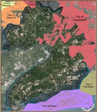
Municipal jurisdictions on and around Johns Island
An important part of the process for managing growth is the Charleston County Comprehensive Plan. South Carolina’s 1994 Local Government Comprehensive Planning Enabling Act (S.C. Code Title 6, Chapter 29) authorizes local jurisdictions to create a planning commission. Local planning commissions are required to publish a comprehensive plan and update it every five years. The first County plan was published in 1999 with subsequent updates in 2004 and 2008. The County Planning Commission and Council are currently in the process of preparing the next update for 2014. The current plan can be seen on the County’s website. Materials for the 2013 / 2014 review can also be seen on the website.
The Comprehensive Plan is intended to guide local governments in the development of zoning codes and land-use regulations. However, the plan lacks the force of law and must be implemented by appropriate legislation. The City of Charleston also has its own Planning Commission and creates their own comprehensive plan. While efforts are made to coordinate the two plans, the City is not bound by the terms of the County’s plan.
One area where there is significant inconsistency is the Urban Growth Boundary (UGB – see map overlay) as defined in the County’s Comprehensive plan. The UGB is intended to manage growth and strengthen protections for the rural areas of the County that lie outside the boundary. This is particularly an issue for Johns Island. Much of the central Johns Island along Maybank Highway has been annexed into the City over the last two decades (see Municipal overlay map). Most of this area is within the Urban Growth Boundary.
 However, there is no legal restriction to the City annexing areas beyond the UGB, and significant parts of Johns Island outside the boundary actually fall under the City’s jurisdiction. Portions of River Road around the airport and an area along Main Road near the high school, for instance, come under the control of the City. This situation creates the kind of political conflicts of interests that were on full display in April 2013, when Charleston City Council approved a planned development outside the UGB despite widespread opposition and against the unanimous recommendation of its own Planning Commission. (see Post & Courier article.)
Given the realities of the governmental process in South Carolina and Charleston County/City, there is no easy solution to improving the way we manage development on Johns Island. One thing that can an help, though, is increased public awareness and informed participation by concerned island residents. The first step is to learn about the basic processes and regulations. We hope these website features and links help.
Secondly, keep up to date about specific development plans and changes in legislation. A free subscription to the Conservancy’s email news list is the easiest way to stay informed about important upcoming event. County Council agendas, City Council agendas and planning commissions agendas are posted on their websites.
The Post and Courier does a good job of publicizing issues. Other organizations such as the Coastal Conservation League the Lowcountry Open Land Trust are also good sources of information and are organizations worth supporting. The Johns Island Conservancy remains committed to developing this website and our newsletter as valuable community resources for news, tools, and analysis.
And finally, participate. Attend Council meetings, go to public hearings, speak out and email legislators when you have an opinion about a pending project or legislation.
Land Use Maps
Much of the information about land use and the development process on Johns Island exists in diferent websites. We have combined map data from multiple sources into one visual tool and made documentation more accessible through indexing and linking. Knowledge is power.
The map is located on our Land Use Map page, and currently consists of nine overlays. Users can select a single overlay or multiple overlays by toggling them on and off with the buttons on the left.
- Jurisdiction – Municipal and UGB layers
These two overlays show the areas under municipal jurisdiction, primarily the City of Charleston. The center of Johns Island along Maybank Highway is a patchwork of the two jurisdictions, with some lots in the County jurisdiction stranded and isolated by haphazard City annexations. Activating both the Municipal and UGB layers reveals where the city has exceeded the urban boundary. These overlays are from:
County GIS (Geographic Information System) website
County Planning webpage
The City website also shows the municipal boundary - Parcels
This overlay shows the property lines for all properties. While many of these properties are undeveloped, the black boundary lines still show a good picture of the current density and potential development on Johns Island. The overlay is from the County GIS website. - Zoning codes
County zoning regulations determine the current land usage and potential development for the unincorporated parts of Johns Island outside the city limits. The overlay map is from the County GIS website. This map can also be used to look up the details of the County Zoning Regulations. (Original data from the Charleston County Zoning and Land Development Regulations website.) - Conservation Easements & Parks
Conservation easements are one of the best ways to preserve land, protect habitat and wildlife and the environment. A conservation easement is a contract between a property owner and a certified third party such as the Lowcountry Open Land Trust. The easement restricts development and is binding on all future owners of the property. In return, the property owner receives limits on their property tax and possibly payment for part of the reduced value of the property. The County’s Greenbelt Fund is the main source of funding for these easements. This map overlay includes data from the Lowcountry Open Land Trust website. - Other Layers:
Major Roads, I-526 Proposal, Road Detail, Historic 1919 Map
The Charleston County websites contain a wealth of information about properties and zoning. Unfortunately this data is spread over a number of different websites. Researching accurate property information often requires going from one website to another and copying codes to get the complete picture.
The key to Charleston County property data is a 10-digit code variously referred to as the property id number (PIN or sometimes PID) or the Tax Map Sequence (TMS). PIN, property id number, is the preferred designation on property tax references and TMS is the designation used on the GIS (Geographic Information System) mapping system. They are all the same 10-digit number for a specific property parcel whether in the unincorporated county jurisdiction or a municipal jurisdiction (e.g. City of Charleston).
Property and Zoning information websites:
- Charleston County Property Information System – Tax Maps
Mapping system (GIS) used to locate a specific parcel by TMS number, owner name or address. The property information on this website is only current as of June 29, 2011, and it refers you to the PropertyMax site for the latest data. Includes recent satellite photos, zoning and municipal boundary overlays. The website can be slow and takes some skill to understand how to use the layers and tools. - Charleston County Zoning and Land Development Regulations
PDF files for each Section of the County Zoning regulations. Chapter 4 specifies the basic zoning districts. Chapter 6 specifies allowed usages for each district and usage conditions. Our online, cross-referenced County Zoning Regulations allows easy access to these multiple chapters. - Charleston County PropertyMax information website
The most up-to-date parcel ownership and property tax information. Under “Real Propertyâ€, it can be searched by PIN number, owner name or street address. This site does not include maps. - Charleston County Auditor website, PRC system
Replaced by the PropertyMax system and refers you to that website. Though it does contain photographic images of the manual property record cards that were used before 1991, accessing them may require reconfiguring your browser. Technical instructions on how to install the necessary components are included on the website. - City of Charleston Interactive Zoning Map
New GIS (graphic information system) that integrates the mapping and data information for properties within the city boundaries. Many of the features available on the Conservancy’s website land use maps and tools, plus more, are available for the City on the City’s Interactive Zoning Map. The Conservancy’s website contains zoning information only for the unincorporated portion of the county. Please see the City’s website for zoning details within the City’s boundaries. - Charleston County Comprehensive Plan
PDF files of the County’s latest Comprehensive Plan (2008) and materials from recent workshops for this year’s revision. - Charleston County RMC (Register Mesne Conveyance)
County records office. Copies of deeds, mortgages and plats.